

Quick Entry
Author Login Peer Review Editorial Login EiC Login
Optics and Precision Engineering

- Editor-in-Chief:Xuejun Zhang, Liangcai Cao
- ISSN:1004-924X
- eISSN:2097-3209
- CN:22-1198/TH
- Supervisor:Chinese Academy of Sciences
- Sponsor:Changchun Institute of Optics, Fine Mechanics and Physics, Chinese Academy of Sciences, China Instrument and Control Society
- Publication frequency:Semimonthly
- Tel.:0431-86176855
- E-mail:gxjmgc@ciomp.ac.cn
- Address:No.3888 Dong Nanhu Road, Changchun, Jilin, China
Rankings  更多
更多
- 0 1 Domestic instrument industry in china: progress, challenges and outlooks 5630
- 0 2 Optimized design and analysis of a compliant steering stage using hybrid actuation 3861
- 0 3 Virtual axis magnetorheological finishing of high-steepness curved optical elements 3384
- 0 4 Grating interferometric precision nanometric measurement technology 3370
- 0 5 Development and prospect of hyperspectral polarization 3161
- 0 6 Large field of view line-scanning confocal holographic microscopy 2870
- 0 7 Survey of target detection based on deep convolutional neural networks 2532
- 0 8 Development of optical waveguide elements in augmented reality near-eye displays 2362
- 0 9 Multimode composite guidance data fusion method and its experimental validation 2345
- 10 MMShip: medium resolution multispectral satellite imagery ship dataset 2302
查看更多
Links
- Latest Articles
- Online First
- Archive
- Special Issues
2026年第34卷第18期
Modern Applied Optics
摘要:In order to achieve accurate identification of aquatic bacteria, this study employed transmission spectroscopy combined with a generative adversarial network (GAN)-based data augmentation approach to classify and identify five typical aquatic bacterial species. Addressing challenges such as the high cost of acquiring transmission spectral samples, susceptibility to instrument performance variations, and insufficient model generalization under small-sample conditions, we proposed a spectral data augmentation strategy based on a dynamic filtering generative adversarial network (DFGAN) and constructed a convolutional neural network (CNN) classification model. Initially, 600 transmission spectra of the five bacterial species were collected across different cultivation periods and concentration gradients to form the original dataset. Subsequently, a deep convolutional generative adversarial network (DCGAN) and the proposed DFGAN were implemented for data augmentation, with the quality of generated spectra evaluated from three dimensions: visual morphology, statistical distribution similarity, and feature space diversity. Finally, comparative analyses were conducted on the recognition performance of three classifiers: support vector machine (SVM), K-nearest neighbor (KNN), and CNN. The results indicated that the quality of spectra generated by DFGAN was significantly superior to that of DCGAN. The aquatic bacteria identification model established by the DFGAN-CNN approach exhibited optimal performance, achieving an accuracy of 95.00%, precision of 95.45%, recall rate of 95.00%, and F1-score of 95.00%, thus demonstrating the highest accuracy and robustness. This method not only provides a novel approach for the rapid detection of aquatic bacteria but also offers technical references for addressing small-sample challenges in the field of spectral analysis.关键词:transmission spectrum;data augmentation;waterborne bacteria;recognition;dynamic filtering generative adversarial network130|42|0更新时间:2026-10-10- 摘要:To address the issues of insufficient accuracy and frequent violations of physical constraints during the interpolation and reconstruction of measured data in Polarized Bidirectional Reflectance Distribution Function (pBRDF) databases—which previously degraded the accuracy and credibility of polarization rendering results—this paper proposed a physics-constrained pBRDF reconstruction method tailored for polarization rendering. First, the pBRDF data was mapped into cylindrical coordinates to eliminate parameter singularities and boundary discontinuities. Second, an initial Mueller matrix was obtained via a local linear interpolation method based on periodic distance metrics. Subsequently, reciprocity symmetrization, Cloude semi-definite eigenvalue truncation, and energy conservation projection were applied sequentially to ensure the physical realizability of the reconstructed results. Finally, the reconstructed data was integrated into a polarized ray tracing pipeline for rendering validation. Experimental results based on the KAIST dataset demonstrate that the proposed method reduces the storage size of single-material data from 912 MB to 650 MB. It achieves a zero physical violation rate for both Gold and Purple Silicone materials. Compared with the TD method, the proposed approach improves the SSIM of the Degree of Polarization images for Gold and Purple Silicone materials by 4.3% and 0.8%, respectively, and the SSIM of the Angle of Polarization images by 4.5% and 5.0%, respectively. By balancing reconstruction accuracy, physical correctness, and storage efficiency, this method provides effective support for the high-precision reconstruction of pBRDF measurement data and realistic polarization rendering.关键词:polarization bidirectional reflectance distribution function;Mueller matrix;cylindrical coordinate representation;physically constrained interpolation;polarization rendering96|44|0更新时间:2026-10-10
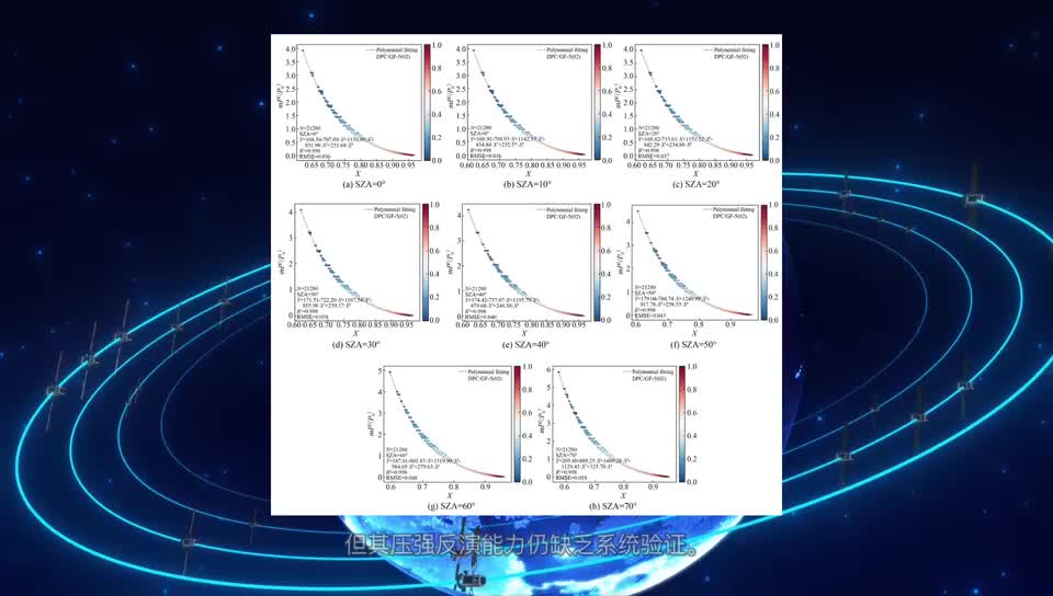
- 摘要:Snow plays an important role in the Earth's energy balance, hydrological cycle, and climate system, and its reflection characteristics are fundamental to characterizing radiative transfer processes at the land surface.Snow also serves as one of the primary ground feature backgrounds on winter battlefields. In natural environments, snow surfaces are often shaped by wind and underlying terrain, forming macroscopic structures such as snow ridges, which can alter photon propagation paths and scattering directions, thereby affecting the polarized reflection of snow. However, the effects of such macroscopic structures on snow polarized reflection and the applicability of existing polarized reflectance models remain poorly understood. To address this issue, this study investigated both flat snow surfaces and snow-ridge surfaces. Three observation scenarios were designed by changing the relative orientation between the solar incidence direction and the ridge direction: a flat snow surface, ridges parallel to the incidence direction, and ridges perpendicular to the incidence direction. A multi-angular polarimetric observation system was used to measure the hemispherical distribution of the polarized reflectance factor under these three scenarios. Based on the measurements, the performance of two widely used polarimetric reflectance models, the Litvinov model and the Nadal–Bréon model, was evaluated. The results show that for flat snow surfaces and snow ridges parallel to the incident direction, the bidirectional polarized reflectance factor exhibits relatively regular hemispherical distributions, primarily characterized by a pronounced enhancement in the forward-scattering direction. When the snow ridges were oriented perpendicular to the illumination direction, the polarized reflectance in the forward scattering direction was substantially weakened, while the polarization was improved in part of the backward scattering direction. Model evaluation indicates that both the Litvinov and Nadal-Breon models achieve high simulation accuracy for flat snow surfaces, with R² values of 0.86 and 0.84, respectively, and relative root mean square errors (RRMSEs) below 29%. However, model performance significantly decreases for ridged snow surfaces. For snow ridges parallel to the incident direction, R² values decrease to 0.73 and 0.64, with RRMSEs of approximately 39%. When the snow ridges were perpendicular to the illumination direction, the weakened forward-scattering and the improved backward-scattering polarization caused the angular distribution of polarized reflectance to deviate from the assumptions of the models. Consequently, both models failed to accurately reproduce the angular distribution of polarized reflectance and exhibited their poorest performance, with R² values of 0.43 and 0.44, respectively and RRMSEs of approximately 50%. Overall, this study reveals the significant influence of snow surface structure on polarized reflectance characteristics and highlights the limitations of existing polarized reflection models in representing ridged snow surfaces. These findings indicate uncertainties in the application of polarimetric remote sensing under complex surface conditions and provide a basis for improving and developing snow polarized reflectance models.关键词:multi-angular polarized reflectance;snow cover;snow ridges;polarized reflectance models140|36|0更新时间:2026-10-10
Micro\/Nano Technology and Fine Mechanics
摘要:Existing seamless steel pipe surface defect detection methods depend on labeled samples. They also rely on a single sensing modality and incur high hardware costs. They further struggle to simultaneously satisfy detection efficiency and accuracy requirements under industrial conditions. To address these limitations, this paper proposed a defect detection method. The method is based on line laser scanning with 2D and 3D fusion. A dedicated optical path was designed to acquire surface data. This design achieved pixel-level alignment of grayscale intensity and depth information. A relative ratio method was proposed to avoid calibrating surface reflectance under complex illumination. A parametric reference template generation mechanism was further established. This mechanism enabled automatic recognition of multiple pipe diameters and batch-level parameter reuse. A hierarchical relative-position computation strategy was proposed for complex inspection environments. This strategy suppressed measurement disturbances induced by conveyor belt vibration. A dual-comparison algorithm was developed, integrating grayscale texture analysis with geometric deviation assessment. This algorithm identified typical surface defects, including grooves, pits, perforations, and scale. Experimental results demonstrate that the system achieves a comprehensive detection accuracy of 99.40%. The system reliably detects surface defects as small as 0.50 mm. This performance is maintained under a pipe transfer speed of 1.2 m/s. The proposed system realizes full circumferential coverage inspection of the steel pipe outer surface. It satisfies the accuracy and real-time requirements of industrial online inspection.关键词:steel pipe surface;defect detection;line laser;three-dimensional vision;pipe diameter measurement112|46|0更新时间:2026-10-10

查看更多
- Featured Album

- Address:No.3888 Dong Nanhu Road, Changchun, Jilin, China Postal code:130033
- Tel:0431-86176855 Email:gxjmgc@ciomp.ac.cn
- Technical support is provided by Beijing Founder electronics co., LTD 吉ICP备11002662号-17
 京公网安备11010802024621
 - It is recommended to read the content of this site in Chrome&IE9+. Please switch to extreme mode in browser 360.
- Cookies We use cookies to help provide and enhance our service and tailor content. By continuing, you agree to the use of cookies.

0